
Get ready, Chicago. The first significant Chicago snow Monday is officially on its way, promising a messy and slippery start to the workweek. Forecasters are calling for the first measurable snowfall of the season to sweep across the area, with up to 3 inches of accumulation possible by the time the morning commute begins. This initial blast of winter weather marks an abrupt end to the mild autumn and serves as the city’s annual reminder to find its shovels and brace for a classic Chicago weather shift.
A Messy Morning Commute: What to Expect
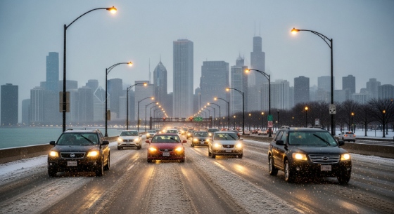
The biggest impact of this first snow event will be on the roads. The snow is expected to develop late Sunday night and continue through the Monday morning rush hour, creating hazardous conditions for drivers. With temperatures dropping, bridges and overpasses will become especially slick. This will be the first slippery commute of the season, catching many drivers off guard. Officials are urging residents to allow for extra travel time, increase following distances, and drive with extreme caution.
How Much Snow Will We Get?
While this isn’t a major blizzard, it’s enough to cause significant disruption. The general forecast calls for widespread accumulations of 1 to 3 inches. However, some areas, particularly in northwest Indiana and the eastern suburbs of Cook County, could see locally higher amounts due to lake effect snow enhancing the snowfall rates as cold air passes over the relatively warm waters of Lake Michigan.
The Scale of the First Snowfall: A Look at the Forecast
The forecast for the Chicago snow Monday event shows a classic early-season setup. An arctic front is providing the cold air and moisture needed to produce the first widespread, sticking snow of the year.
- Timing: Snow is expected to begin after 10 p.m. Sunday and continue through Monday morning.
- Accumulation: Most of the area will see 1 to 3 inches.
- Main Impact: A slow, slippery, and potentially dangerous Monday morning commute.
- The Cause: A combination of system snow from a cold front, followed by the potential for lake effect snow showers, will lead to a prolonged period of light to moderate snowfall.
The End of Fall: Winter Arrives in Chicago
For many Chicagoans, the first measurable snow is the unofficial start of winter. This Chicago snow Monday event signals a definitive shift in the seasons. The mild temperatures of recent weeks will be replaced by a colder, more typical November weather pattern. It’s a psychological turning point for the city—a collective signal to prepare for the months of cold and snow that lie ahead. While some may greet the snow with excitement, many more will be mourning the end of autumn and the beginning of the long Chicago winter.
How to Prepare for the First Snowfall
After a long break from winter weather, it’s easy to forget the basics of snow preparedness. Now is the time to get ready before the first flakes fly. Make sure your vehicle’s tires are properly inflated and have good tread. Check your windshield wiper fluid and find your ice scraper. At home, locate your shovel and salt. A little preparation Sunday can save you a major headache during the messy Chicago weather on Monday morning.
Conclusion
There’s no more denying it: winter is knocking on Chicago’s door. The upcoming Chicago snow Monday is set to deliver the first real taste of the season, bringing with it the familiar challenge of a messy and hazardous commute. While the snowfall totals won’t be record-breaking, this first snow event is a critical reminder to slow down, be prepared, and adjust to the reality of winter driving. Welcome to winter, Chicago.